

Staff Reporter
During the UAE’s presidency, the UAE Space Agency led the Charter’s activities in coordination with the National Emergency Crisis and Disaster Management Authority, the MBRSC, and Space42.
Recent earthquakes in Egypt and Colombia have once again highlighted the importance of rapid, accurate information during natural disasters. The 5.6-magnitude earthquake in Egypt and the 7.4-magnitude earthquake in Colombia on August 10, 2026, underscored the need for technologies that can help emergency authorities quickly assess damage, identify affected areas and coordinate relief operations
Space science and technology are increasingly playing a critical role in meeting these needs. Satellite imagery, geospatial information, data analytics and artificial intelligence are enabling governments and humanitarian agencies to obtain timely intelligence, assess disaster impacts and make faster, more informed decisions
The value of these capabilities has been further reinforced through the International Charter: Space and Major Disasters, a global mechanism that uses space-based reactive contributor to this international effort, strengthening its role after assuming leadership of the Charter through the UAE Space Agency from April to October 2026
During its presidency, the UAE Space Agency led an international system that deployed satellite imagery and geospatial data to assist countries affected by a wide range of natural disasters. The initiative sought to improve the speed and accuracy of emergency assessments while supporting efforts to protect lives, infrastructure and property
The International Charter: Space and Major Disasters is among the world’s leading initiatives for applying space technology to disaster response. Its 17 member organisations provide satellite imagery and related data free of charge to authorised agencies around the world. The information helps authorities assess damage, map affected areas and coordinate emergency and humanitarian operations
Under the UAE’s leadership, the UAE Space Agency coordinated Charter activities with the National Emergency Crisis and Disaster Management Authority (NCEMA), the Mohammed Bin Rashid Space Centre (MBRSC) and Space42. The collaboration brought together space technology, emergency-management expertise and geospatial analysis capabilities to strengthen international disaster-response operations
The UAE presidency has also been marked by several Charter activations supporting countries affected by floods, wildfires, earthquakes, volcanic activity, cyclones and other emergencies
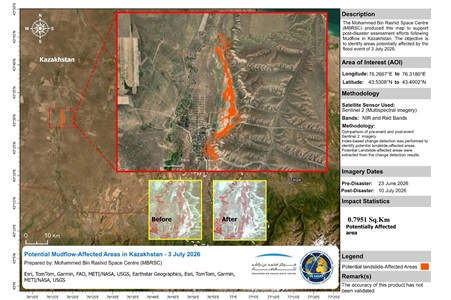
In Kazakhstan, the Charter was activated in early July 2026 after heavy rainfall caused flooding and riverbank erosion in the Almaty Region. Working with the MBRSC, satellite imagery was supplied to help assess the affected areas and monitor the extent of flooding. The resulting near-real-time information supported authorities in making decisions, managing the emergency and protecting communities and infrastructure
Kazakhstan had previously benefited from a Charter activation on June 9 following wildfires in the Akmola Region. Space42 worked with the Charter to rapidly deliver satellite imagery and geospatial data, allowing authorities to assess affected areas, track the progression of the fires and improve the speed and effectiveness of emergency operations
The Charter also supported Venezuela after two earthquakes struck the country’s north-central region on June 24. As part of the response, Space42, in cooperation with the UAE Space Agency, supplied high-resolution satellite imagery covering the affected areas. The Technology Innovation Institute (TII) and TACTICA, also working with the UAE Space Agency, conducted an initial assessment to identify potential damage. The operation demonstrated how satellite data and artificial intelligence can complement one another to deliver timely information for emergency decision-making.
In Kyrgyzstan, the Charter was activated following flash floods and mudflows that affected several areas on May 25. In cooperation with the MBRSC, satellite imagery and geospatial data were used to identify impacted locations and assess damage. The information provided emergency teams with reliable intelligence that supported crisis management and accelerated response efforts
The UAE-led effort also extended to the Philippines following the eruption of Mayon Volcano. Satellite imagery supplied in cooperation with the MBRSC helped authorities monitor volcanic activity, assess affected areas and evaluate the effects of ashfall and related risks to nearby communities. The information contributed to emergency preparedness and efforts to protect lives and property
New Zealand also received support following severe flooding in April 2026. The Charter, working with the MBRSC, used satellite imagery and geospatial data to map affected areas, monitor flooding and landslides, and provide authorities with information needed to manage the crisis. The data supported both immediate response and recovery activities while helping mitigate the consequences of extreme weather
In Papua New Guinea, the Charter activated its mechanisms following the impact of Cyclone Mayla. Member organisations used satellite imagery to identify areas vulnerable to flooding and support emergency operations. The resulting information helped authorities respond more effectively while assisting affected communities and supporting recovery efforts
Together, these operations demonstrate the increasingly important role of space technology in modern disaster management. Satellite imagery has evolved beyond simply observing natural phenomena to become a strategic reand delivering timely information to emergency teams and decision-makers
The UAE’s leadership of the Charter reflects its expanding role in the global space sector and its efforts to promote international cooperation in using space capabilities for humanitarian purposes. By combining satellite recy-management capabilities, the UAE is helping demonstrate how space technology can strengthen disaster preparedness and response worldwide
Since its establishment, the International Charter: Space and Major Disasters has conducted more than 1,168 activations, supporting 146 countries through a network of more than 270 satellites supplied by its members and partners. The initiative continues to serve as a global example of how international cooperation and space technology can be mobilised to support humanitarian action and strengthen responses to natural disasters
TagsfeaturedpostInternational CharterMajor DisastersMBRSCNCEMSpace42UAE Space Agency
SpaceX completes $60bn acquisition of AI coding platform Cursor
